Thermo Scientific Maps Software is an imaging and correlative workflow software suite compatible with the full line of Thermo Scientific SEM, DualBeam (FIB SEM) and TEM platforms.
Researchers and scientists are increasingly depending on nanoscale observations to guide investigations and analyses. However, it is now apparent that high-resolution observations lose much of their utility without the larger macroscopic context. Observations from multiple sources must be linked, providing the necessary multi-scale and multi-modal insight for truly valuable data.
Maps Software offers a robust, user-friendly platform with a powerful imaging workflow automation package. Users can gather meaningful data with a few clicks while maintaining the context of their observations.
Maps for Materials Science
Multi-Scale Imaging Automation
Regardless of whether it is scanning electron microscopy analysis in SEM and DualBeam tools or transmission electron microscopy (TEM), Maps Software supports automated 2D imaging for various applications, from acquiring large image mosaics to scheduling routine imaging tasks for off times (overnight, weekends).
- Choose rectangular, circular, or custom tilesets for mapping acquisition (STEM/SEM)
- Automatically acquire up to four simultaneous signals (STEM/SEM)
- Run multiple samples in series to increase system productivity
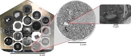
Diatom identification in sand with multi-scale analysis in Maps Software. Image Credit: Thermo Fisher Scientific – Electron Microscopy Solutions
Correlative Microscopy
With Maps Software, users can easily navigate from SEM to TEM and correlate data from optical and electron microscopes to obtain the necessary context for research and development. Leverage multi-modal data for interpretation and navigation, ensuring the collection of precise information from specific locations and enhancing the accuracy of the data acquisition process.
- Align data with system stages using any Thermo Scientific EM platform
- Import 2D and 3D data from any source
- Integrate observations in a multi-scale, multi-layered visualization environment
- Quickly generate context for the entire sample grid or targeted region of interest
- Register imagery from other modalities (e.g., energy-dispersive spectroscopy, secondary electron signal, electron backscatter diffraction, backscatter electron signal, etc.)
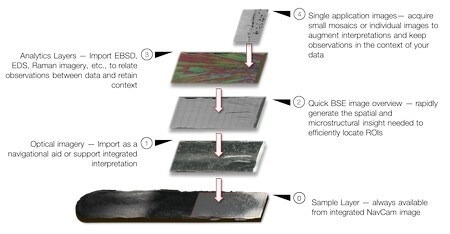
Correlative microscopy of an Inconel 718 part, combining optical and electron microscopy imaging with EBSD analysis. Image Credit: Thermo Fisher Scientific – Electron Microscopy Solutions
Integrated Analytics
Together with high-resolution imaging, Maps Software facilitates integrated EDS map acquisition on STEM platforms for elemental analysis and chemical characterization.
- Easily view EDS maps away from the microscope with the optional offline version of Maps Software
- Employ built-in stitching and multichannel visualization
- Automate large-area, high-throughput EDS acquisition with the Thermo Scientific Super-X and Dual-X Detector Systems
- Enable native correlation with electron imaging layers
Intuitive Visualization and Offline Collaboration
The optional offline version of Maps Software allows users to take the microscope with them when they are away from the lab.
- Easily share multi-scale observations with colleagues
- View data from your own PC
- Plan your next imaging session before you head to the lab
- Access the full correlative power of Maps Software anywhere
Avizo Software Integration
Image processing and statistical data generation are automated with the addition of Thermo Scientific Avizo Software. In addition to processing images acquired in the background, Avizo Software offers a comprehensive, integrated user experience that combines sophisticated analysis with acquisition.
- Tune and optimize imaging and processing workflows
- Gain instant access to critical statistical data through a complete, automated imaging and analysis solution
- Perform advanced image processing, accessible while users are on the tool
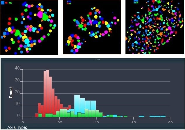
Avizo Software provides automated nanoparticle analysis in TEM. Here, EDS analysis counted the number of particles containing chlorine (light blue), nickel (green), and gold (red) and produced a histogram of their relative particle sizes. Sample courtesy of J. Bursik, Institute of Physics of Materials, Brno. Image Credit: Thermo Fisher Scientific – Electron Microscopy Solutions
Key Features
- Automated acquisition of large overviews at any magnification (tile and stitch); multiple acquisitions can be set up for unsupervised batch data collection.
- Compatibility with current Thermo Scientific SEM, FIB-SEM, and TEM platforms, providing a unified user experience across all instrument types.
- Correlation of images from different microscopes, including imported images from 3rd party instruments using the integrated Bio-Formats Library.
- An integrated approach to data acquisition, annotation and storage.
- Setup and coordination of experiments across multiple microscopes.
- Large area EDS mapping.
Multi-Scale Imaging Automation
An entirely automated solution for producing high-quality, multi-scale images.
Correlative Microscopy
Attain valuable insights by integrating observations across different modalities and imaging platforms.
Integrated Analytics
Simplify and instantly enhance the value of EDS mapping through direct acquisition and integration of elemental layers.
Intuitive Visualization and Offline Collaboration
The optional offline version of Maps Software enables users to continue their investigation and plan the next imaging session even when they are away from the microscope.
Maps Offline Viewer
This free, standalone application lets users view Maps projects from their PC (Windows 7 or 10). After installation, simply launch the application and import projects for viewing.
Maps Offline Viewer allows users to open Maps projects on any PC. It also allows easier sharing of results without requiring a licensed version of Maps. Note that the viewer does not allow processing steps like stitching, etc.
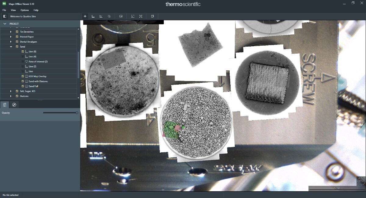
Screenshot of Maps Offline Viewer Software. Image Credit: Thermo Fisher Scientific – Electron Microscopy Solutions