Forage Mass Monitoring (FFM) analysis has been traditionally done using biomass sampling to calculate biomass yield per hectare (t ha-1). Current research projects are now looking at reflectance spectroscopy methods using remote sensing systems based on unmanned aerial vehicles (UAVs). Promising results in recent years prove the principal suitability of such systems for airborne monitoring of small to medium-sized farmland in agricultural applications for precision agriculture, such as biomass for crops and grasslands. An imaging system in the form of a multispectral multicamera system is often used to derive well-established vegetation indices (VIs) efficiently. However, due to the use of silicon-based sensors, the spectral application range of such multi-camera systems is limited to the visible (VIS) and near-infrared (NIR) wavelength range (400-1000nm). Therefore, more robust indicators linked to biomass in the short-wave infrared (like cellulose or moisture content) cannot be considered as estimators.
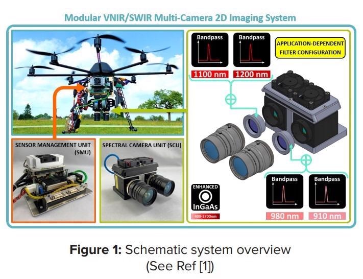
In a joint research project, a team from the University of Applied Science Koblenz and the Remote Sensing and GIS group at the University of Cologne developed a UAV-based multi-camera system to collect NIR/SWIR data, to prove more robust and better-performing estimators of biomass monitoring. The system displayed in figure 1 shows a spectral camera unit (SCU) and a sensor management unit (SMU), both mounted onto a drone solution. The SCU deploys two Raptor Owl 640 M Vis-SWIR cameras enabling the coverage from 600 to 1700 nm of the electromagnetic spectrum. These camera modules were chosen because of their optimized “Size, Weight and Power” parameters. Thanks to the small form factor, the energy-efficient uncooled (TEC-less) design, and the high sensitivity, these modules are ideal for integrating multiple camera modules into a lightweight, UAV-based remote sensing system for daylight operations. Another advantage is the interchangeable lens mount used for a custom filter flange solution to adapt application-specific narrow bandpass filters in the optical path.
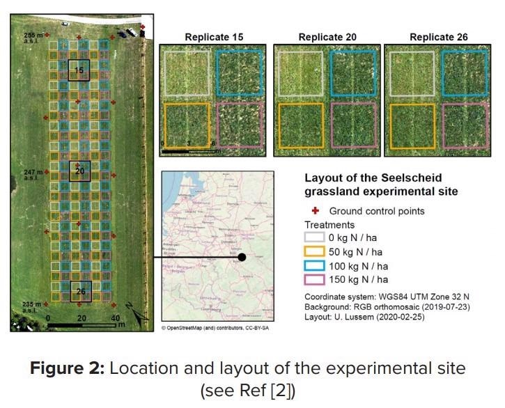
The study aimed to validate the spectral performance and investigate spectral image data of a newly developed VNIR/SWIR multi-camera prototype for forage mass monitoring. For this purpose, aerial image data were acquired by the system on a permanent experimental grassland site near Cologne (chessboard trial), Germany, under clear sky conditions in July 2019. Spectral ground truth data were acquired with an ASD Fieldspec3 (FS3) spectroradiometer in twelve selected plots. Forage mass expressed in dry matter yield (DMY) was obtained by destructive biomass sampling 14 days after the flight date from all 156 trial plots.
To evaluate the VNIR/SWIR camera system’s spectral properties, the reflectance values of the individual spectral bands and the two derived VIs, NRI (Koppe et al. 2010)3 and GnyLi (Gnyp et al. 2014)4, were directly compared with the corresponding FS3 values. Moreover, the camera- and FS3-based VIs were further analyzed in simple linear regression models as estimators for DMY. The camera-based SLR resulted in an R2 of 0.71 to 0.75. These are promising results for a single flight date data set. However, further multi-temporal studies with advanced evaluation methods have to be carried out to confirm these results. Moreover, further estimation models for nitrogen concentration and crude protein content have to be evaluated. Evaluations for cereal crops are currently under investigation. Ultimately, these first promising evaluation results demonstrate these novel InGaAs sensors’ suitability for use in multi-camera systems for UAV-based vegetation monitoring. They provide easy-to-use data with excellent spatial resolution in the selected wavelength bands over the entire spectral range from 600 – 1700nm.
Read the full application note here.
Why not discuss your potential Raptor camera application with us. Contact [email protected] for more information on how to set up a Teams call!