From mineral composition and alteration signatures to subsurface physical properties, the review shows how AI can extract more value from materials-related evidence while exposing the gaps that still limit fully integrated exploration.
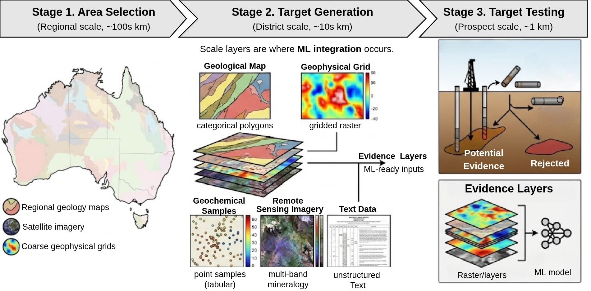
Mineral Exploration Pipeline and Data Modalities. An overview of the exploration workflow demonstrating the spatial scales and data types utilized at each stage. Stage 1 (Area Selection) uses regional-scale (∼100s km) geology, satellite imagery, and coarse geophysics to identify broad regions of interest. Stage 2 (Target Generation) operates at the district scale (∼10s km) and relies heavily on data integration; raw heterogeneous data, including geological maps (categorical polygons), geophysical surveys (gridded rasters), geochemical assays (tabular point samples), remote sensing (multi-band imagery), and unstructured text - are processed into stacked ‘evidence layers’ that serve as inputs for machine learning models. Stage 3 (Target Testing) involves prospect-scale (∼1 km) physical validation, such as drill core sampling, to confirm or reject predicted deposits.
In a recent review preprint posted on Preprints.org, researchers Taghipour et al. explore the application of artificial intelligence, including foundation models and machine learning, to integrate heterogeneous geoscientific data to advance mineral exploration and prospectivity mapping. The paper has not undergone peer review.
Mineral Exploration Challenges
The escalating global demand for minerals, especially critical minerals essential to technology and clean energy, intensifies the need to discover new mineral deposits. Mineral exploration integrates diverse geoscience data types, such as geophysical grids, geochemical assays, remote sensing satellite imagery, and geological maps, to identify prospective mineralization zones.
Traditional interpretation by domain experts is time-consuming and difficult to scale over large, underexplored terrains. The heterogeneous nature of these geoscience datasets, coupled with complex geological spatial dependencies, presents unique challenges for AI methods.
Specifically, the scarcity of labeled positive samples, the multimodal data formats, and spatial non-stationarity impede the straightforward application of machine learning models. Because the absence of a known deposit does not mean an area is barren, mineral exploration is naturally a positive-unlabeled learning problem. Spatial autocorrelation can also yield overly optimistic results when training and test samples are randomly split. Advances in AI, particularly foundation models and deep learning, could eventually help integrate these diverse data sources for mineral prospectivity mapping and deposit discovery, although no single foundation model currently spans all exploration modalities.
AI Techniques for Exploration
This survey synthesizes current artificial intelligence approaches applied across the mineral exploration pipeline with a focus on geoscientific data processing and integration. It first delineates the five principal geoscience modalities relevant for exploration: geophysical surveys, including gravity, magnetics, and electromagnetics; geochemical assays, including multi-element rock and soil samples; hyperspectral and multispectral remote sensing, including surface mineralogy via satellite imagery; categorical geological maps, including rock and structure classification; and textual sources such as geological reports and survey records.
Within geochemical analysis methods, AI techniques target anomaly detection of element concentrations, mineral classification based on trace element signatures, and predictive thermobarometry to estimate formation temperatures and pressures from mineral chemistry.
The review highlights models such as the Deep Autoencoder Network connected to Geographical Random Forest (DAN-GRF), which adapts anomaly thresholds regionally, and tree-based machine learning (ML) ensembles employed for thermobarometric regression from mineral oxide concentrations.
For geophysical and remote sensing data, the survey covers deep learning models capable of integrating multi-resolution gridded data to capture subsurface physical properties and surface mineral signatures. These include convolutional neural networks (CNNs) applied to multispectral imagery and transformer-based or spectral-unmixing methods applied to hyperspectral data to delineate alteration zones, indicators of hydrothermal processes associated with mineralization.
The mineral prospectivity mapping (MPM) framework is extensively reviewed as the integrative approach for fusing these domain-specific evidence layers derived from different geoscience datasets. Classical probabilistic methods, such as Weights of Evidence, ensemble tree methods (including Random Forests and XGBoost), and deep architectures, are reviewed as approaches for target generation.
The paper emphasizes recent advances in foundation models, large-scale pre-trained AI architectures relevant to geoscience data. These include Earth observation models trained on vast satellite imagery, seismic foundation models that interpret geophysical data, and domain-specific large language models (LLMs) that reason over geological text. The review distinguishes between models already demonstrated in exploration, architectures that are technically suitable but remain untested, and capabilities that do not yet exist.
Natural language processing (NLP) tools are also described for converting geological reports and textual knowledge into quantitative evidence, linking geological descriptions to spatial prediction.
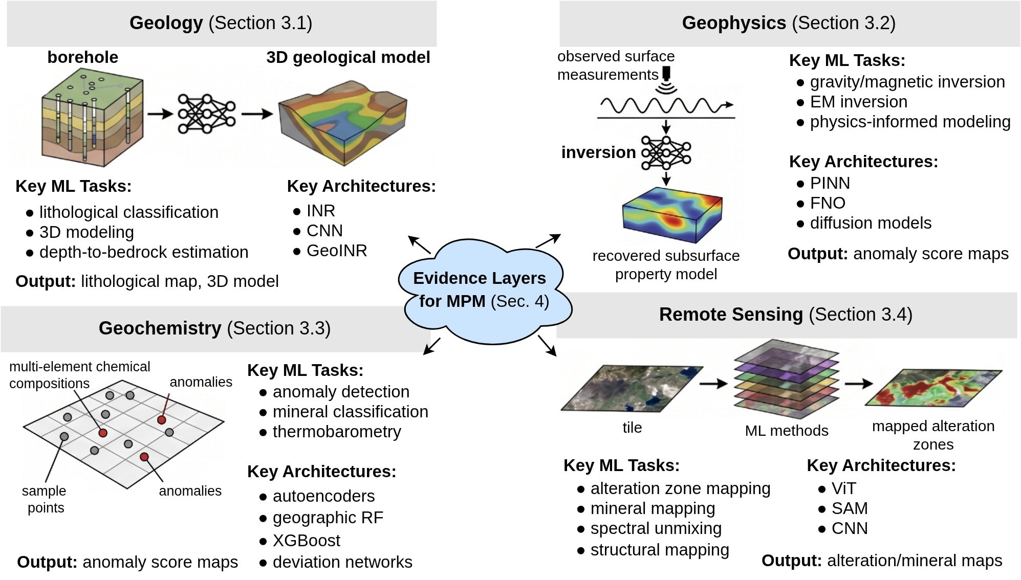
A visual summary of the key ML methods, tasks, architectures, and resulting data products across the four geoscience domains: geology, geophysics, geochemistry, and remote sensing.
Foundation Model Capabilities and Gaps
The review indicates that AI methods can improve the extraction and integration of geoscientific evidence layers necessary for mineral exploration. In geochemical applications, the studies reviewed report that spatially informed AI models can detect elemental anomalies with local spatial context, potentially improving on fixed-threshold techniques.
Classification models trained on accessory mineral chemistry can distinguish between ore-bearing and barren systems, while XGBoost and LightGBM have been used to predict deposit type and resource size from zircon chemistry. ML-based thermobarometry methods have been reported to improve the reliability of estimates of mineral-forming conditions, supporting the reconstruction of thermal histories and geological environments.
Remote sensing approaches employing deep learning produce detailed lithological and alteration maps by distinguishing mineral spectral signatures, which can help identify zones affected by hydrothermal fluids associated with mineralization. Hyperspectral analytics enable fine-scale mineral discrimination, supporting characterization of alteration minerals, which are important exploration indicators.
In geophysical domains, foundation models and self-supervised pre-training techniques support seismic tasks such as classification, segmentation, inversion, denoising, and interpolation, helping characterize subsurface physical properties that are critical to understanding the geometry of mineral deposits at depth. However, the survey highlights that no dedicated foundation model currently exists for gravity, magnetic, or electromagnetic data, core geophysical proxies for mineral exploration.
Integrative mineral prospectivity mapping fuses these multimodal evidence layers and benefits from ensemble methods, deep architectures, and self-supervised approaches that may reduce dependence on labeled deposits. However, spatial autocorrelation, biased negative-sample selection, and inadequate spatial validation remain significant limitations. Transfer learning across geological regions has been attempted in only a few studies and remains largely untested due to non-stationary spatial relationships between geoscientific signals and mineralization. Most deep learning studies also focus on a single commodity in a single study area, limiting their demonstrated generalizability.
Natural language processing tools form a novel pathway by transforming unstructured geological and mineralogical textual data into features that complement numerical datasets, potentially improving prospectivity prediction models. However, fully multimodal foundation models that can jointly reason across imagery, geophysical grids, geochemical assays, geological maps, and textual data are yet to be realized. Only the pathway from geological text to prospectivity prediction has demonstrated end-to-end integration with mineral exploration.
Future Directions and Impact
The integration of AI, particularly foundation models and multimodal learning, presents a significant research opportunity for mineral exploration by supporting more effective use of heterogeneous geoscience datasets.
Current advances demonstrate progress in individual geoscience modalities, including geochemical assays, remote-sensing spectral data, and geological texts, with AI applied to anomaly detection, classification, and parameter estimation from geochemical and mineral-composition data.
Future progress depends on the development and validation of multimodal foundation models that can jointly interpret diverse geoscience datasets and agentic AI systems capable of orchestrating complex exploration workflows. Neither capability has yet been demonstrated across the full mineral exploration pipeline. Progress will also require standardized benchmarks, spatially aware validation, uncertainty quantification, and closer collaboration between geoscientists and AI researchers.
Source:
- Taghipour, A., Scott, R., Ghahremani, M., Jessell, M., Boussaid, F., Laga, H., & Bennamoun, M. (2026). Artificial Intelligence for Mineral Exploration: Methods, Foundation Models, and Future Directions. Preprints 2026072303. DOI: 10.20944/preprints202607.2303.v1. https://www.preprints.org/manuscript/202607.2303