The GS Series has been introduced by the GSSI as the next-generation class of high-performance antennas that target applications that need deeper penetration depths. The first antenna in the series is known as the 200 HS.

Image Credit: Geophysical Survey Systems
This digital and wireless antenna features a 200 MHz center frequency and applies GSSI’s proprietary HyperStacking® technology. This technology enhances signal-to-noise performance and raises depth penetration under all soil conditions. The GS Series seems to be perfect for geotechnical, geophysical and environmental applications that need high reliability under difficult survey conditions.

Image Credit: Geophysical Survey Systems
Applications
- Archaeological investigations
- Water table mapping
- Sinkhole areas
- Deeper utility detection
- Bedrock profiling
- Stratigraphy
- Bathymetry
Components
- Panasonic® Toughpad G1
- Controller: SIR® 4000 (with WiFi Module)
- Tow handle
- 200 HS Antenna
- Dual-bay battery charger
- Lithium-ion battery (4)
Purpose-Built Tools for the Geophysical Industry
The 200 MHz HyperStacking Antenna offers greater resolution data compared to what is earlier available and has greater depths at a lower frequency range.

Image Credit: Geophysical Survey Systems
Acquire Data Wirelessly
Users can determine geophysical characteristics easily with the help of a wireless HS Module and 200 HS. The HS Module links the SIR 4000 or Panasonic Toughpad G1 to the antenna and enables the user to leverage a single HS Module throughout all GS Series antennas.

Image Credit: Geophysical Survey Systems
HyperStacking Technology and Improved Depth
The GS Series makes use of the patented HyperStacking Technology to offer clearer data, from superficial features to deeper characteristics. The 200 HS antenna helps to achieve greater depth penetration, almost double compared to traditional GPR antenna designs.

Image Credit: Geophysical Survey Systems
System Versatility
The GS Series accommodates new and existing users with two controller choices; SIR 4000 is available with a WiFi module, or Panasonic Toughpad tablet. Thanks to its IP 65 rating, the 200 HS antenna has the ability to resist dust and is highly water-resistant.

Image Credit: Geophysical Survey Systems
Advanced Features
The GS Series integrates advanced features that have been particularly developed for survey efficiency, such as an integrated GPS, and can house an external GPS mount. Users can visualize data on the tablet with the help of a GIS map mode. Also, they can use accessories to tailor survey collection modes.
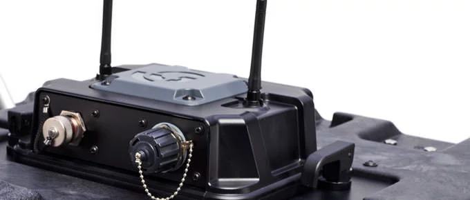
Image Credit: Geophysical Survey Systems
Data Examples
Integrated GIS
Tablet screen image of 2D GPR data indicative of flood plain deposits located in the Northeast US (left) and geographic information system (GIS) data (right).
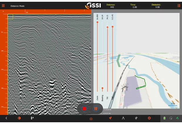
Image Credit: Geophysical Survey Systems
Real-Time Data Processing
The data for stratigraphic analysis of fluvial deposits in Northeastern United States was collected using the SIR 4000 and 200 HS antenna.
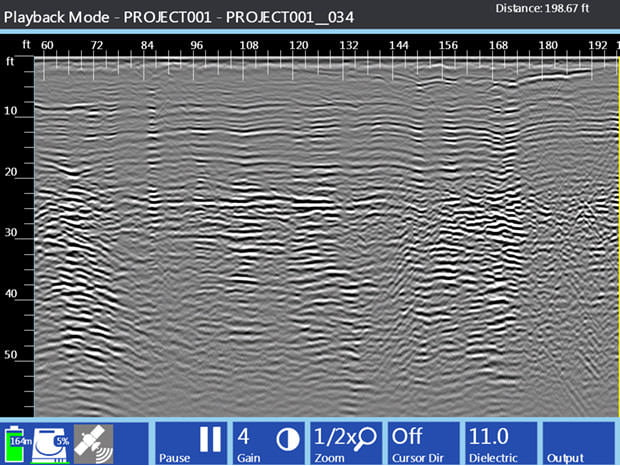
Image Credit: Geophysical Survey Systems
High-Resolution and Deeper Depth of Penetration
This detailed and deep (400+ ns) stratigraphic section from Alton, New Hampshire, USA, showed well-stratified glacio-lacustrine deltaic sets above possible glacial till and bedrock. This profile shows the excellent depth penetration of the 200 HS antenna while highlighting the antenna’s superior near-surface resolution.
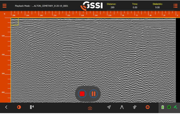
Image Credit: Geophysical Survey Systems
Specifications
Source: Geophysical Survey Systems
| 200 HS Antenna |
| Center frequency |
200 MHz |
| Max depth |
21 m (70 ft)* |
| Battery life |
4 hours |
| Environmental rating |
IP65 |
| Vibration |
Mil-STD-810G Method 514.6C Category 9 |
| Operating temperature |
-10 °C to 40 °C external (14 °F to 104 °F) |
| Weight |
17.9 kg (39.6 lbs) |
| Dimensions |
64.8 x 64.8 x 34.3 cm (25.5 x 25.5 x 13.5 in) |
| Model |
50200HS |
| Data acquisition |
| Data format |
RADAN® (dzt) |
| Output data format |
32-bit |
| Scan interval |
Up to 200 scans/sec |
| Number of samples per scan |
512, 1024, 2048, 4096, 8192 |
| Operating modes |
Continuous (time), Survey Wheel (distance triggered), or Point Mode |
| Time range |
0-16,000 nanoseconds full scale, user-selectable Gain: manual adjustment from -42 to +126 dB Number of segments in gain curve is user-selectable from 1 to 8 |
| Signal-to-noise ratio |
171 dB |
| Standard real-time filters |
Infinite Impulse Response (IIR) - Low and High Pass, vertical and horizontal |
| Advanced real-time features |
Surface Position Tracking, Signal Noise Floor Tracking, Adaptive Background Removal, Dynamic Gain Control |
| Internal GPS accuracy |
Autonomous 2.5 m (8.2 ft), SBAS 2.0 m (6.6 ft) |
| External GPS |
Bluetooth |
| Wireless range |
15 m (50 ft) |
| Input/Output |
USB, rugged Ethernet, survey wheel and marker input, digital connector |
* Under ideal soil conditions
Accessories
200 HS Wheel Kit
The wheel kit is consistent for the 200 HS antenna and also for the future GS Series antennas. This kit is available with four wheels and correct mounting brackets to fit onto the antenna. The wheel kit will help reduce the wear on the bottom of the antenna and is constructed for simpler travel in high wear data collection areas like concrete and asphalt.

Image Credit: Geophysical Survey Systems
GS Series Transit Case
This custom foam Pelican Case has been developed for the GS Series accessories. This transit case retains the Panasonic Toughpad Tablet, SIR 4000 WiFi Module, HS Module, tow handle, optional wheel kit, batteries and battery charger.
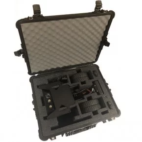
Image Credit: Geophysical Survey Systems
Model 620 Survey Wheel
The Model 620 survey wheel offers distance encoding and accurate linear positioning along a transect. This survey wheel is proper for all mid-to-low frequency antennas.

Image Credit: Geophysical Survey Systems